2002 Crater Excursion - Northern Etna
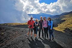
The 2002 crater tour is one of the most popular destinations chosen by tourists on the northern slopes of Etna, far from the chaos of the southern slope, allowing you to savor the authenticity of the Etna volcanic environment in total tranquility, immersed in uncontaminated nature. Our guests accompanied by our Guides will be immersed in a whole new world, passing by the remains of the tourist infrastructures, the castings, the green of the woods and finally the craters surrounded by lunar landscapes, all in a path of just over 4, 5 km round trip.
Possibility to rent boots / jacket on the spot.
Program:
Meeting at the Etna Nord Volcanological Guides office in Piano Provenzana at 10:30 am.
Departure from Piano Provenzana at 1800 meters at 11:00.
Initial briefing.
Beginning of the trek.
Visit to eruptive fractures up to a maximum altitude of 2100 meters.
Descent on trekking to the starting point.
Total duration: 3h
Difficulty: T (Tourist).
Itinerary
This is a typical itinerary for this product
Stop At: Via Provenzana 37 Localita Piano Provenzana, 95015 Linguaglossa, Sicily Italy
Beginning of the trek along the dirt road that from Piano Provenzana leads to the summit craters of the volcano, after the first kilometer you cross the eruptive fracture of the eruption of 27 October 2002 on the Monte Nero - Timpa Rossa path, the route allows you to visit and study, the many volcanic morphologies, related to the eruptions that followed one another on the northern slope of Etna, in particular the eruptions on the side of 10 September 1911 and 17 June 1923 which threatened the town of Linguaglossa. After visiting the particular morpho-volcanic structures called Hornitos from the Spanish "Small oven", we will climb along the pyroclastic cones of the 2002 eruption until we reach the maximum altitude of 2100 meters on the edge of the craters, and then descend inside of a sandy channel to the starting point.
The route has a total length of 4.5 km.
Useful information:
Minimum trekking start altitude: 1800 mt - maximum altitude reached: 2100 mt.
Total height difference uphill: 300 meters (variable value) - Height difference: 300 mt.
Total Km: 4.5
Compulsory equipment:
Layered clothing (short-sleeved shirt - long-sleeved thermal shirt - fleece or sweatshirt) - (variable according to the season)
Trekking shoes
Windbreaker or down jacket (variable depending on the season)
Water - minimum 1.5 L
Duration: 3 hours
Duration:2 to 3 hours
Commences in:CT, Italy
Country:Italy
City:CT
Booking, Reviews, More..
Worlds Largest Network Home

Hike Jasper | Tour Canadian Rockies | Jasper Columbia Icefield | Maligne Lake Boat Cruise | Jasper Wildlife | Book Banff National Park | Book Jasper National Park | Banff Gondola | Lake Minnewanka Boat Cruise | Athabasca River Rafting | Jasper Wildlife Tours| Rocky Mountain Train Tickets | Maligne Ice Walk | Shopping Jasper | Columbia Icefields Glacier Skywalk | Jasper SkyTram | Jasper Maligne Lake Cruise | Johnston Canyon | Golden Skybridge | Tour Moraine Lake