5-Day Best of Taiwan: Sun Moon Lake, Taroko Gorge, Kaohsiung, Taitung
This 5-day Taiwan tour will take you around the whole island, opening your eyes to the countrys diverse, astounding beauty and culture. Visit Sun Moon Lake and admire the remote beaches and rocky coastal scenery of places like Tarako National Park. Tour historic shrines and Buddhist temples such as Fo Guang Shan Monastery, explore bustling urban districts, and relax in natural hot springs. Youll stay in 5-star hotels and travel aboard a comfortable coach, stopping in several locations for sightseeing tours with your English-speaking guide. Daily breakfasts and all entrance fees to attractions listed in the itinerary are included.
Itinerary
Day 1: Taipei - Sun Moon Lake
Stop At: Sun Moon Lake, Zhongshan Rd., Yuchi Township, 555 Taiwan
Divided by Lalu Island, the Sun Moon Lake scenic area got its name from the unique terrain that looked like a sun on one side and a crescent moon on the other. Crowned as one of the Eight Wonders of Taiwan, Sun Moon Lake is also the most famous source of hydroelectric power; offering key tourist themes high mountain and lake, indigenous culture, and nature ecology, the Sun Moon Lake Scenic Area attracts more than six million visitors each year.
Duration: 30 minutes
Stop At: Yidashao Pier, Yidashao, Riyue Vil., Yuchi Township Taiwan
Yidashao(Ita Thao), is called Barawbaw in thao language. The Han people call it North Cave. It was named Te Hua village after the restoration of Taiwan, and is under the administration of Yuchi. It has become the most populous area around the Sun Moon Lake. There are stores, restaurants, and hotels in the village. Also the thao people establishes the "thao Cultural Village" for tourists to appreciate the traditional culture, songs, and dancing of the thao tribe.
Duration: 1 hour
Stop At: Xuanzhuang Temple, No.389 Zhongzheng Road, Riyue Village, Yuchi Township Taiwan
Monk Xuanzang was the Holy Monk in the Tang dynasty. During the China-Japan War, Japanese took the Monk Xuanzang's remains away from Nanchin to the Tsen Temple of Saidama Ken in Japan. In 1955, the Monk Xuanzang's remains were returned back to the Xuanguang Temple. In 1965, the Monk Xuanzang's remains were moved to the Xuanzang Temple after the temple rebuilding. There is a bell in front of the main gate of the Xuanzang Temple. The bell is called "wake up bell." If you prefer quiet atmosphere, Xuanzang temple is the best places for you.
Duration: 30 minutes
Stop At: Ci'en Pagoda, Yuchi Township, 555 Taiwan
Ci-en Pagoda is located on Sha Ba Lan Mountain near Sun Moon Lake. It was built by Chiang Kai-Shek in memory of his mother in 1971. The construction was very difficult because the materials had to be shipped over the lake and moved up the mountain. The Ci-en Pagoda is 46 meters in height and has become the famous landmark of Sun Moon Lake. Surrounding the tower are beautiful plants and trees and there are stone tables and chairs for visitors to take a rest. The Ci-en Pagoda overlooks Lalu Island and Sun Moon Lake.
Duration: 1 hour
Stop At: Wenwu Temple, No.63, Jhongshan Rd. Yuchih Township, Nantou City Taiwan
Wenwu Temple is located at the shoulder of mountain where is on the north of Sun Moon Lake. It was built in 1938. People worried the water of Sun Moon Lake might cover Longfeng Temple and Ihuatang of Shuishotsun, they built Wenwu Temple. The Wenwu Temple is 2 (Longfeng Temple and Ihuatang) in 1. It was rebuilt in 1969. Its gate is face to the north. People pray the Civil Saint of Confucius, the Military Saint of Guangong, and the Established God of two temples at the Wenwu Temple. The temple is popular among students.
Duration: 40 minutes
No meals included on this day.
Accommodation included: Hotel Fleur de Chine - Mountain View Room, Sun Moon Lake (5-star) or equivalent
Day 2: Sun Moon Lake-Fo Guang Shan-Kaohsiung
Stop At: Xiangshan Visitor Center, No.599, Jhongshan Rd., Yuchih Township Taiwan
The Xiangshang Visitor Center is both for tourism and administration use. The uniquely designed building has wood-patterned exteriors and wings that stretch like human arms embracing the earth. In addition, the two giant canopy structures, 34 meters long and 8 meters tall each, allow people to enjoy beautiful views of the Sun Moon Lake from the top.
Duration: 45 minutes
Stop At: Fo Guang Shan, No.153, Xingtian Road, Dashu District, Kaohsiung 84049 Taiwan
At the north-east of Dashu District Kaohsiung City on the left bank of the Gaoping (Kaoping) river, a famous tourist destination is located. Here you will find the Buddhist center of South Taiwan, established by Master Hsing Yun and his disciples. The architecture of the temples is very characteristic, and at the southeastern side of Fo Gunag Mountain (Gunag Shan) Monastery the most prominent landmark of the region is found: a huge golden statue of Buddha Amitaabha which measures some 120 meters.
Duration: 1 hour 45 minutes
Stop At: Ai He (Love River), Min Sheng 2nd Road, Kaohsiung Taiwan
Love River begins at Bagualiao in Kaohsiung City's Renwu District. It divides Kaohsiung City, into two. The Jianguo, Cisian and Jhongjheng Bridges connect the two sections and the river flows directly into the sea. Love River had originally been a shallow creek, which could only be crossed by ferry. During the Japanese Colonial era it was dredged into a canal and named The Kaohsiung River. This was the first time the river had been given an official name. It was formally referred to as The Kaohsiung Waterway or The Kaohsiung Canal. In 1948, Love River Boat Company was opened near the Jhongjheng Bridge. This gave people the opportunity to row up and down the river. This became a particularly popular past for local couples and therefore acquiring the name - Love River.
Duration: 30 minutes
Stop At: Liuhe Tourist Night Market, Liuhe Rd, Qianjin Dist, Kaohsiung 800 Taiwan
Liuhe Night Market is Kaohsiung's oldest, most typical night market. When night falls, Liuhe(Liuho) Street, close to the traffic of the city center, changes into a culinary heaven given over to pedestrians, encompassing all of the port city of Kaohsiung's most characterful, trademark cuisine; and innovative international cuisine has also added an international tint to Liuhe Night Market. The Market won five awards in the ROC Tourism Bureau's 2010 Unique Night Market Selection Activity: Most Civilized, Most Environmentally-Friendly, Friendliest, most Charming, and Most Stroll-Friendly. It cannot be missed if you want to experience Taiwan's unique night market culture!
Duration: 1 hour
Meals included:
• Breakfast
Accommodation included: Grand Hi Lai Hotel, Kaohsiung (5-star) or equivalent
Day 3: Kaohsiung-Kenting-Taitung
Stop At: Kenting National Park, No.596, Kenting Rd., Henchun Township Taiwan
Established on Jan. 01, 1948, is Taiwans first National Park. The park is superbly located. Spanning the Hengchun Peninsula, it faces the Pacific Ocean to the east, the Bashi Channel to the south, and the Taiwan Straits to the west. Some of Taiwans largest coral reefs lie off the coast and the forests along the parks western edge are the last of Taiwans coastal tropical forests. The name Hengchun Peninsula says much about the areas attractions. The fantastic climate, lush forests, beaches, and reef environments make Kenting a rival to internationally famous tropical resorts like Bali and Phuket.
Duration: 30 minutes
Stop At: Eluanbi, Eluan Road, Hengchun Township Taiwan
Kending's rugged coastline provides some of the area's most outstanding attractions. The most prominent of these must be Eluanbi, also known as "Taiwan's Tail". This is the island's southernmost point. Eluanbi Park was created in 1982 to provide an appropriate venue for people coming to visit Taiwan's southernmost point and one of the peninsula's most notable landmarks, the Eluanbi Lighthouse, also called "The Light of East Asia". It stands 21.4 meters high and is reputedly the brightest lighthouse in Asia. The park covers an area of 59 hectares. Within the park there are a number of recreational facilities and a wide range of interesting geological, botanical, and ornithological features. The area covered by the park is also one of the sites of Kending's prehistoric cultures.
Duration: 45 minutes
Stop At: Maobitou Park, No. 100, Xiaquan Road, Hengchun Township, Pingtung County, Taiwan 946
Maobitou is located in the west cape of southern Taiwan, right on the demarcation point of Taiwan Strait and Bashi Channel. Since there is a rock falling from the sea cliff which looks like a crouching cat facing toward the sea, it is named Maobitou. The whole area of Maobitou is a typical erosional landform of coral coast which just faces windward and has abundant sea erosion. It is an excellent landform classroom with various scarps, reef columns, sea trenches, sea erosion caves and pot holes.
Duration: 40 minutes
Stop At: Longpan Park, Jia'e Highway, Hengchun Township Taiwan
Longpan is the great grassland beside the Jia-Oh highway and near the beach of Pacific Ocean. This area is based on the tableland of coral reef limestone. Eroded by the rain, the terrain of limestone shows a variety of crumbled ridges, subterranean limestone caves, and red soil.
Duration: 20 minutes
Meals included:
• Breakfast
Accommodation included: Hotel Royal Chihpen, Taitung (5-star) or equivalent
Day 4: Taitung - East Coast National Scenic Area Hualien
Stop At: East Coast National Scenic Area, Chenggong Township Taiwan
The East Coast National Scenic Area, known as "Taiwan's last unspoiled land," stretches 170 kilometers down the east coast of the island from the mouth of the Hualien River in the north to Xiaoyeliu (Little Yeliu) in the south. To the east it is bounded by the Pacific Ocean; to the west rises the Coastal Mountain Range. The land here consists of volcanic rock, classic rock from deep beneath the sea, and shale that has been pushed upward- and is still being pushed upward- by tectonic action. Weathering, erosion, and accumulation have produced a wide range of landforms here, including coastal terraces, sand and pebble beaches, shoreline reefs, inshore islands, and capes along with sea-eroded platforms, trenches, and caves. This varied topography provides habitat for a rich diversity of flora and fauna.
Duration: 30 minutes
Stop At: Fanshuliao, No. 18, Fangliaoken, Shuilian Vil., Shoufeng Township Taiwan
Located at the 28-kilometer mark down the Provincial Highway No.11, Fanshuliao offers views of two strongly contrasting types of topography, both created by the Fanshuliao River: a wide valley made up of accumulated sediment, and a narrow, vertical-walled gorge which has been cut through the mountains by the relentless wearing action of the flowing water. The gorge is somewhat similar to the famous Tailuge (Taroko) Gorge, and offers the most remarkable vistas of this type of terrain on the East Coast. A local legend has it that the aborigines living here in the distant past so revered courage that they promised to make chief whoever could vault across the gorge. Many young braves tried; all fell to heir death. The bamboo poles that they used in their attempts survived, however, becoming a living bamboo grove that still thrives in the gorge today.
Duration: 20 minutes
Stop At: Sanxiantai, Northeast of Chengdong Town Taiwan
Situated at the 111-kilometer mark on the coastal highway, Sanxiantai consists of a headland facing a small island in the sea. The three huge rocks that make up the island's most prominent feature have given rise to a local legend that three of China's Eight Immortals once landed there; hence the name of the island, which means "terrace of the three immortals." The island was once connected to the headland by a neck of land which has been eroded away; it is now connected by a red, scalloped footbridge, and the island has a network of footpaths for viewing its geological features such as potholes and sea-eroded caves and trenches, as well as rare coastal vegetation. The island is surrounded by coral reefs and a multitude of tropical fish, making this an ideal spot for skin diving.
Duration: 45 minutes
Stop At: Xiaoyeliu, No. 500號, Section 1, Songjiang Road, Taitung City, Taitung County, Taiwan 950
Located at the 159-kilometer mark near the southern end of the East Coast National Scenic Area, Fugang Geopark (Little Yehliu) offers a rich variety of fascinating rock formations similar to those found at Yehliu on Taiwan's North Shore. Unlike the rest of the Philippine Plate that determines the geology of this area, the rock of Fugang Geopark is sandstone. This prompts geologists to believe that it originated somewhere else. You should first study the detailed explanations of the geological displays in the Visitor Center before going to the seashore and examining the tofu rock, honeycomb rock, fungus rock, and other strange ormations there. On clear days, you can easily see Green Island from the shore at Fugang Geopark.
Duration: 45 minutes
Stop At: Yanzihkou Trail, Xincheng Township Xiulin Township, Hualien City Taiwan
Along the Yanzihkou Trail(Swallow Grotto Trail) which runs about a half kilometer starting from the entrance to Yanzihkou Trail to the Jinheng Bridge, you can enjoy the sights of the Liwu River from nearly straight above the water, the potholes on the cliff faces, the springs sprinkled along the lower parts of the walls, as well as the famous rock formation "Chieftain's profile rock".
Duration: 40 minutes
Meals included:
• Breakfast
Accommodation included: Silks Place Taroko - Garden View Room(5-star), Hualien or equivalent
Day 5: Hualien Taroko Taipei
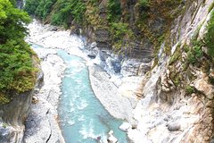
Stop At: Taroko National Park, No.291, Fushi Fushi Vil., 97253 Taiwan
Taroko became a national park in 1986, including Hualien County, Nantou County and Taichung City. Taroko is famous for its spectacular mountains and marble canyons. Cliffs and canyons stretch along Liwu River. Four million years ago, the island of Taiwan was formed by the collision of plates. After millions of years of wind erosion, the marble rocks were exposed and cut by Liwu River, creating impressive grand canyons. From Qingshui to Nanhu Peak, the drop height is 3,742 meters. Such special geography has also bred special flora and fauna in this area.
Duration: 30 minutes
Stop At: Cihmu Bridge, Xincheng Township Taiwan
Along Central Cross-Island Highway, after passing Jiuqudong (Tunnel of Nine Turns), you will arrive at Cimu Bridge(Motherly Devotion Bridge), which is an H-Shape hanging bridge with marble stone lions on each end and with marble lotus stones on two sides. The rock beneath the bridge looks like a frog. The frog-like rock is composed of black layer of schist at the top and white marble at the bottom. A pavilion was built on this frog rock, becoming the crown on the frog. This was built by late President Chiang Jing-guo, in memory of his mother, during construction of the road. Cimu pavilion area is on the east side of the bridge, built by late President Chiang Kai-shek, in memory of his mother, Mrs. Wang.
Duration: 20 minutes
Stop At: Eternal Spring Shrine, in Taroko National Park Taiwan
The starting point of this trail is the tunnel that leads from the highway to the Changchun Temple(Eternal Spring Shrine). This is definitely a trail for those who don't mind exerting themselves; for although it is not long, it is extremely steep. Those who suffer from vertigo should probably avoid this trail as well, for it has an intimidating bridge-crossing, and part of the trail also follows a mountain ridge, which falls away steeply on either side.
Duration: 30 minutes
Stop At: Lushui Trail, 172K Zhongheng Road, 972 Taiwan
Lushui Trail was part of the Old Cross-Hehuan Mountain Road. The width of the path is about 2 meters which is about the same as during the Japanese Era. (1895-1945) The trail has a gentle slope and is easy to walk. It is a sight-seeing path that is suitable for all ages. There is a 30 meter tunnel along the trail, so please bring a flash light.
Dense forest, cliff terrain, plants growing on the rock and historical monuments are the characteristics of the Lushui Trail. You can view the historical monuments of Tailuge (Taroko) National Park and observe the special botanical ecosystem. Walking on this historic path you follow in the footprints of earlier people.
Duration: 1 hour
Stop At: Qingshui Cliff, Su-hua highway from Herping to Chungte, 97253 Taiwan
Qingshui Cliff is a 21 kilometer length of coastal cliffs averaging 800 meters above sea level in Xiulin Township, Hualien County, Taiwan. The tallest peak, Qingshui Mountain, rises 2408 meters directly from the Pacific Ocean. The cliff is located at the southern part of the Suhua Highway that connects the counties of Yilan and Hualien in eastern Taiwan. It is considered to be a very scenic area and is the highest coastal cliff in Taiwan.
Duration: 20 minutes
Meals included:
• Breakfast
No accommodation included on this day.
Duration:5 days
Commences in:Taipei, Taiwan
Country:Taiwan
City:Taipei
Booking, Reviews, More..
Worlds Largest Network Home

Hike Jasper | Tour Canadian Rockies | Jasper Columbia Icefield | Maligne Lake Boat Cruise | Jasper Wildlife | Book Banff National Park | Book Jasper National Park | Banff Gondola | Lake Minnewanka Boat Cruise | Athabasca River Rafting | Jasper Wildlife Tours| Rocky Mountain Train Tickets | Maligne Ice Walk | Shopping Jasper | Columbia Icefields Glacier Skywalk | Jasper SkyTram | Jasper Maligne Lake Cruise | Johnston Canyon | Golden Skybridge | Tour Moraine Lake